Turkey hosts one of the longest single-country sections on the Trans Euro Trail. The route threads through three distinct coastal climates, crosses one of Europe’s most remote mountain ranges, and passes within reach of some of the best wild-camp bays in the Mediterranean basin.
This turkey tet route guide covers what the ride actually demands — section-by-section terrain, fuel and accommodation logistics, seasonal timing, and the preparation that separates a rewarding ride from a brutal one. Riders new to the TET network as a whole should also read the beginner’s TET guide before this section-specific overview.
Introduction: Why Turkey Is a TET Highlight
The Turkey TET is unusual in the network for three reasons. First, it spans more climate zones than any single-country section. The dry Aegean coast, the warm Mediterranean, the wet Black Sea forest belt, and the alpine Kaçkar Mountains all appear within one ride. Second, the surface mix runs roughly 60% dirt and gravel to 40% paved, which is heavier on dirt than most TET countries except Romania and Albania.
Third, the Turkey TET intersects with infrastructure that exists almost nowhere else on the network. Tea houses every 30 kilometres in the interior. Family-run pensions in coastal towns for $20-30 per night. Bays accessible only by motorcycle that combine wild swimming, pine-forest camping, and complete solitude. The Turkish bays only reachable by adventure motorcycle post covers five of the standout spots.
The ride rewards riders who arrive prepared and punishes riders who underestimate the distances between fuel stops, the heat of summer coastal sections, and the technical difficulty of the Kaçkar climbs.
Turkey TET Overview: Distance, Terrain, and Difficulty
The full Turkey TET runs roughly 3,200 kilometres from the western Aegean coast through to the eastern Black Sea border with Georgia. The route is published in multiple segments by the Turkey linesman to allow riders to enter and exit at various points.
Surface composition averages 60% dirt and gravel and 40% paved across the full route, but the percentages shift dramatically by region. Aegean sections run closer to 40% dirt. Mediterranean sections are roughly 50/50. Black Sea and Kaçkar sections push 70% dirt or higher.
Difficulty grading using a five-point scale where 1 is easy gravel and 5 is technical enduro: Aegean coast 2-3, Mediterranean coast 2-3, Datça Peninsula off-shoots 4, Cappadocia plateau crossings 3, Black Sea forest sections 3, Kaçkar Mountains 4-5. Beginners should plan to ride only the 2-3 sections on a first trip.
Fuel range planning matters more in Turkey than in central or western Europe. Petrol stations in coastal cities are abundant; in eastern interior sections, particularly the Anatolian plateau between major towns, stations can be 80-120 km apart. Bikes with under 250 km of long-term fuel range should carry a 1-2 litre auxiliary fuel canister for the eastern sections.
Section 1: Aegean Coast — Datça to Bodrum
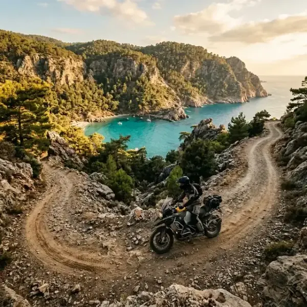
The Aegean section is the most-recommended starting point for Turkey TET. The route runs from the southern Datça Peninsula north through the wine country east of Bodrum, then onward to Çeşme and Foça further north. Total Aegean section distance is roughly 600 km of TET track.
The terrain is dry pine forest on rocky soil, with occasional sand patches near the coast. Olive groves break up the forest. The signature landscape feature is the limestone outcrops that frame countless small bays. Most of them accessible only via dirt access roads that the TET route either follows or runs parallel to.
The Datça Peninsula off-shoots are the technical highlight. Narrow dirt descents drop several hundred metres of elevation in a few kilometres, dumping the rider onto small pebble beaches with no infrastructure. The descents demand real skill on a loaded bike. The Datça low-side that closes the Klim review happened on exactly one of these tracks.
Aegean fuel logistics are easy. Stations are 30-50 km apart at most. Coastal pensions are abundant at $20-35 per night. Wild camping in the bay coves is broadly tolerated outside July and August peak season.
Section 2: Mediterranean — Antalya to Kaş
The Mediterranean section runs east from Antalya along the Lycian coast to Kaş and Demre, then further east through the Taurus foothills toward Adana. Total Mediterranean TET distance is roughly 800 km.
The terrain shifts from the dry pine of the Aegean toward more humid Mediterranean forest with cypress and oak. The roads include serious climbs into the Taurus range — some passes hit 1,800 metres of elevation. The descents back toward the coast traverse twisting dirt switchbacks with loose surface and exposed drop-offs.
The Mediterranean section is the hottest in summer. Antalya in July sees 38-42°C, which on a loaded bike in full gear becomes genuinely dangerous after 4-5 hours. Riders attempting this section in summer should plan early-morning departures (5-7 AM), midday rests in shade, and afternoon resumptions only after 16:00. The Klim Badlands Pro review covers the gear-side response to this heat — venting jacket design becomes a survival feature, not a comfort one.
Mediterranean fuel range is fine on the coast but tightens in the Taurus interior. Carry auxiliary fuel for the inland sections. Wild camping is tolerated in the Taurus mountain meadows but restricted along the heavily-touristed coast east of Antalya.
Disclosure: some links below are affiliate links. If you buy through them we may earn a small commission at no extra cost to you.
Shop Adventure Tyres on Amazon →
Section 3: Black Sea — Trabzon to Kaçkar Mountains
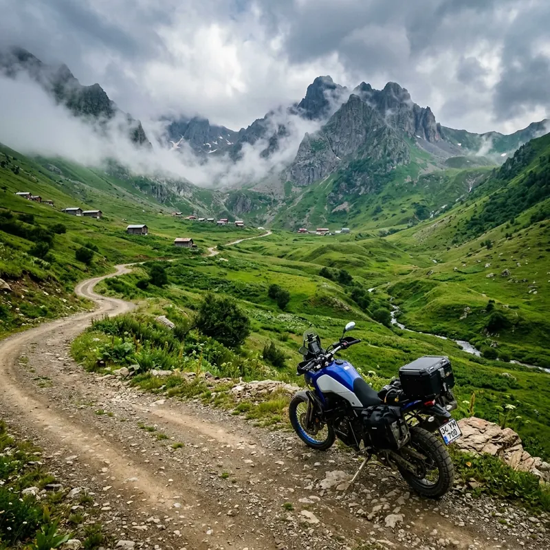
The Black Sea section is the most technically demanding and the most rewarding. The route enters from the Mediterranean via the central Anatolian plateau, crosses to the Black Sea coast near Samsun, and runs east to Trabzon before climbing into the Kaçkar range south of Hopa.
The terrain on the coastal strip is dense temperate forest with frequent rain. The Black Sea coast averages 250+ rain days per year, more than anywhere else in Turkey. The forestry tracks here turn from hard-packed gravel into slick clay within hours of a thunderstorm. Riders should plan for at least two weather days in any week-long Black Sea section.
The Kaçkar Mountains rise sharply south of the coast, reaching 3,700 metres at the highest peaks. The TET route runs through high alpine pasture, crosses several mountain passes above 2,500 metres, and descends through yaylas (summer pastoral villages) accessible only by dirt roads that are impassable in winter. The technical difficulty here matches the hardest sections in Romania.
Fuel range becomes critical. Stations are 60-100 km apart in the coastal forest belt and 100-150 km apart in the Kaçkar interior. Carry full reserve. Accommodation is sparse. The yaylas have simple pensions in season, but late-season riders may need to wild camp or descend to the coast each night.
The Black Sea climate also affects gear choice. The Klim or similar fully-laminated jacket that suffers in Antalya heat becomes the right choice here, where 8 hours of rain is a routine riding day.
Turkey TET Preparation Checklist
Pre-trip preparation for the Turkey TET emphasises three areas: fuel range extension, navigation reliability, and emergency communication in remote sections. The full preparation kit specific to Turkey is below.
- Downloaded Turkey TET GPX from transeurotrail.org
- Offline maps loaded — OsmAnd or Gaia GPS
- Spare fuel canister 1-2L for eastern sections (900 g full)
- Turkish SIM card for emergency comms (20 g)
- Cash in Turkish Lira for rural fuel stops (minimal weight)
- Tyre plug kit and CO2 x3 (180 g)
- Garmin Zumo XT2 or protected phone mount waterproof (400 g)
The Turkish SIM card matters specifically because rural gas stations and pensions often refuse foreign credit cards. Cash in Turkish Lira covers fuel purchases, accommodation in small pensions, and meals in village restaurants where card readers do not exist. The SIM also enables emergency calls and offline-map updates over cellular when WiFi is unavailable.
The full tool kit beyond this Turkey-specific list is covered in the essential motorcycle tool kit for overlanding guide. The Turkey-specific additions are auxiliary fuel and the SIM card.
Check Garmin Zumo XT2 on Amazon →
Shop Fuel Canisters on Amazon →
Wild Camping in Turkey: What to Know
Wild camping in Turkey is broadly tolerated away from urban areas and tourist beaches. The rural population is generally welcoming to motorcycle travellers, the legal framework is permissive for short stops on public forest land, and the jandarma (rural gendarmerie) rarely interferes with riders who follow basic etiquette.
The exceptions are real and worth respecting. Marked national parks have designated camping zones and prohibit wild camping outside them. Archaeological sites are off-limits even when they look like empty hillsides. Private agricultural land — olive groves, vineyards, orchards — requires landowner permission, which is usually granted with a polite ask but cannot be assumed.
Coastal differences matter. Aegean and Mediterranean coasts have heavy summer tourist traffic that makes wild camping near popular beaches problematic — both legally and socially. The remote coastline between Datça and Marmaris, the Lycian coast east of Kaş, and the entire Black Sea coast east of Sinop offer abundant wild-camp spots in forest clearings and remote headlands.
Fire restrictions are seasonal and strict. From June through October, no open fires are permitted anywhere on Aegean and Mediterranean coasts due to wildfire risk. Camp stoves are fine. Wood fires can result in serious fines and immediate ejection from the site. Black Sea coast fire restrictions are less strict due to higher humidity but still respected in dry summer windows.
Best Time to Ride Turkey TET
Seasonal timing determines whether the Turkey TET is rewarding or punishing.
April through June offers the best overall riding window. Coastal temperatures sit in the 18-26°C range, wildflowers cover the Mediterranean hillsides, and tourist traffic stays low until mid-June. The Kaçkar Mountains may still have snow on high passes through May, but by mid-June the full network opens.
September through October offers the second window. Summer heat has broken, the Mediterranean is still warm enough for bay swimming, and harvest season brings the interior alive with markets and festivals. The Black Sea coast remains rideable through October before autumn rains intensify.
July and August are the worst window for the Aegean and Mediterranean sections. Coastal temperatures reach 38-42°C, tourist traffic clogs every coastal town, and prices for accommodation double or triple. The Kaçkar Mountains are pleasant in summer, but reaching them requires crossing the coast at peak heat. Riders committed to summer should plan dawn departures and route through the Black Sea coast where the climate stays cooler.
Winter (November through March) closes the Black Sea and Kaçkar sections due to snow. The Aegean and Mediterranean coasts remain rideable through mild winter weeks, but rain frequency increases significantly and many coastal pensions close for the season. Winter Turkey TET is possible but is a 50%-route ride at best.
Conclusion
The Turkey TET rewards the prepared rider with terrain, hospitality, and landscape variety unmatched on most of the European network. It punishes the unprepared with brutal heat in summer, deep mud on the Black Sea coast, fuel anxiety in the eastern interior, and technical difficulty in the Kaçkar climbs that humble even experienced overlanders.
The right approach is to break the route into seasonal chunks, build skill on the easier Aegean coast before attempting Kaçkar, and respect both the climate and the local communities whose continued tolerance keeps the route open.
For riders ready to commit, Turkey is one of the genuine highlights of the TET network. Pair this guide with the beginner’s TET overview, the essential tool kit list, the remote Turkish bays guide, and the eastern Anatolia route for the high country beyond the trail — Nemrut, Lake Van and Doğubayazıt — to build a complete preparation picture before the bike leaves home.
If the TET is one leg of a longer trip rather than the whole plan, our ultimate Turkey motorcycle tour guide covers how the off-road sections sit alongside the coastal and interior routes, and what a realistic country-wide itinerary looks like.
Disclosure: Some of the links in this article are affiliate links. If you buy gear through them, we may earn a small commission at no extra cost to you. It helps fund the research that makes these independent guides possible — every recommendation here is based on rider reports and published information from the regions covered.
Frequently Asked Questions
How long does it take to ride the Turkey TET?
The full Turkey TET, covering all three coastal zones plus the Kaçkar Mountains, totals roughly 3,200 kilometres of mixed dirt, gravel, and paved sections. At a comfortable pace of 150-200 km of TET track per day, the full traverse takes 18-22 riding days. Adding rest days, weather days, and time for bay swims and village stops, most riders budget 24-30 total days. Splitting the route into two trips — Aegean and Mediterranean as one trip, Black Sea and Kaçkar as a second — works well for riders with limited time.
What is the hardest section of Turkey TET?
The Kaçkar Mountains section on the Black Sea coast is consistently named as the most technically demanding. The terrain includes long rocky climbs at altitude, mud after frequent Black Sea rain, deep ruts on unmaintained forestry tracks, and exposed mountain shelves where recovery from a serious crash is difficult. The Datça Peninsula in the southern Aegean is the second hardest — narrow steep dirt descents to isolated bays demand real off-road skill on a fully loaded bike.
Do I need a visa to ride through Turkey?
EU, UK, and US citizens get visa-free entry to Turkey for 90 days within any 180-day period as tourists. The motorcycle itself enters on a temporary import permit issued at the border, valid for the duration of the rider's visa stay and tied to the rider's passport. Carrying the bike's registration document, the rider's home country license, an International Driving Permit (recommended though not strictly required for most nationalities), and motorcycle insurance valid in Turkey (green card or short-term Turkish policy at the border) covers the documentation requirements at all road checkpoints.
Is Turkey TET suitable for a beginner?
Not as a first off-road trip. The Aegean coastal sections are doable for riders with 6-12 months of off-road experience, but the Datça descents, Kaçkar climbs, and remote eastern sections require real skill on loose surfaces, sand, and mud. Beginners committed to Turkey should ride the northern European TET sections (Netherlands, Germany, Denmark) first to build skill, then attempt Turkish coastal sections, and only progress to Kaçkar after at least one full season of intermediate off-road experience. See the [beginner's TET guide](/blog/trans-euro-trail-tet-beginners/) for the recommended skill progression.
Where can I download the Turkey TET GPX files?
GPX files for every TET country including Turkey are available free from transeurotrail.org. Each country has a designated volunteer 'linesman' who maintains the route and publishes updates. Download the latest Turkey GPX file before crossing the border — routes change as landowners revoke or grant access, and seasonal closures affect mountain sections. The TET website also lists contact information for the Turkey linesman, which is the correct channel for reporting closed or impassable sections discovered during the ride.