The first time I rode into Cappadocia, I came in from the south on a hot June afternoon, dropped down onto the plateau through Soğanlı, and rolled into Ürgüp with the sun already on the long shadows of the chimneys. I had read four blog posts on the way in. Two of them told me to “chase tracks freely through the valleys.” One of them told me to wild camp under a fairy chimney. All of them were wrong. Some had been wrong for years.
Cappadocia is not an off-road playground. It is a 1,000-metre volcanic plateau full of protected, internationally listed archaeology, and it is one of the most rewarding road-touring bases in Turkey precisely because the riding stays on tarmac and the landscape does the heavy lifting. This guide is what I wish those four posts had said.
If you’re stitching this into a longer Turkish ride, the Lycian Way motorcycle route guide sits a day’s ride south on the Mediterranean, the Black Sea & Kaçkar route sits a longer day north, and the full Turkey TET guide crosses the Anatolian plateau roughly through this region. Cappadocia is the rest day in the middle of all of them — and rest day here means short, beautiful rides between viewpoints, not a transit dash.
What Cappadocia Actually Is, for a Rider
Cappadocia is a historical region in Central Anatolia that spans parts of Nevşehir, Kayseri, Aksaray and Niğde provinces. Its tourist heart — the bit you came to see — sits inside the triangle between Nevşehir, Ürgüp and Avanos, in Nevşehir Province, and it has been a UNESCO World Heritage Site since 1985 under the name Göreme National Park and the Rock Sites of Cappadocia. The protected zone covers roughly 100 km² and includes Karain, Karlık, Yeşilöz, Soğanlı and the underground cities of Kaymaklı and Derinkuyu.
Geologically it is a high volcanic plateau, around 1,000 to 1,100 metres above sea level, capped in places by old lava flows. The “fairy chimneys” are hoodoos of soft tuff with a harder cap rock, sculpted out of the plateau by wind and water over millions of years. That altitude matters for a rider: even in May, mornings on the plateau are cold, and a sunny afternoon can still drop fifteen degrees by the time you’ve finished dinner.
What this means in practice is that the roads here are gentle. You ride a network of well-paved provincial roads and farm asphalt between villages perched on the edge of valleys, and you stop at viewpoints. The riding rhythm is short, slow, photo-heavy. If you’re coming off a hard Black Sea or Lycian leg, Cappadocia is where you wind down.
The Legal Reality, Up Front
This needs to be on the page, not in a footnote, because the rest of the trip depends on it.
The Kapadokya Area is a legally protected zone, established by Law No. 7174 on the Cappadocia Area (dated 23 May 2019), and administered by the Kapadokya Alan Başkanlığı — the Cappadocia Area Directorate. The law’s whole point is to protect the historical, cultural and geological-geomorphological fabric of the region. The area’s boundaries are fixed by a coordinate map annexed to the law itself.
Tourism-purpose sporting activities — ATV, UTV, jeep safari, balloon and so on — are governed by the Sporting Activities Regulation (Official Gazette 13/11/2020, No. 31303) and a set of Usul ve Esaslar (procedures and principles) published by the Directorate. The relevant lines for any rider thinking about pointing a wheel off the road:
- ATV/UTV tourism sporting activity cannot take place outside the track declared by the Area Directorate, and cannot take place inside museums and archaeological sites (Art. 5/1).
- Only licensed operators with the required permits may run these activities.
- During stops, vehicles must not leave the track; any off-track movement must be on foot (Art. 5/14).
- Unauthorised vehicles carrying out tourism sporting activity are immediately stopped and banned (Art. 5/26).
- Operating off the declared track triggers enforcement under Art. 8(1)(f) of Law 7174 and Art. 13 of the regulation (Art. 5/27).
Read plainly: if you take your own motorcycle off the asphalt into the valleys, around the chimneys, or onto a track between Çavuşin and Devrent that “looks like a trail” — you are inside a regime that exists specifically to stop that, and you are riding through a site the country has signed an international treaty to protect.
The honest takeaway: ride Cappadocia on its public roads, and if you want the off-road dunes-and-chimneys experience, book a licensed ATV or UTV tour on an approved track. It’s also the thing that keeps these activities legal at all — every viral video of a private rider tearing through Love Valley is a tiny push toward a total ban.
Season, Climate and What the Plateau Does to Your Gear
The climate is Central Anatolian continental. Hot dry summers, cold snowy winters, and a big temperature swing between day and night even in the shoulder seasons.
- Late April to early June: the best overall window. Daytime around 15–25 °C, clear skies most days, wildflowers on the plateau, manageable crowds. Mornings can still drop close to freezing, especially in April.
- Mid-September to October: the second window. Stable warm weather, dust settled by autumn breezes, the tuff catches the low light beautifully. Late October starts feeling cold at altitude.
- July–August: hot, up to ~30–35 °C, peak crowds and peak balloon traffic. Plan rides for sunrise and after 17:00, take a long midday break in a cave-hotel courtyard, and don’t bother trying to park anywhere central at noon.
- November–March: cold, often snowy, roughly −5 to +6 °C on the plateau. Spectacular for photos, hard for a rider — ice risk on shaded back roads, frequent balloon cancellations, many smaller pensions closed.
That diurnal swing is the gear story. You’ll ride out of Göreme in the dark at 04:30 for a sunrise viewpoint at +3 °C, and ride back at noon at +24 °C. Layering matters here more than waterproofing. A heated grip-equipped bike is a luxury on April mornings; a vented summer jacket is a survival item in July afternoons. The full layering kit is covered in the motorcycle camping gear checklist, and the load-it-up logic in the pack my bike tool.
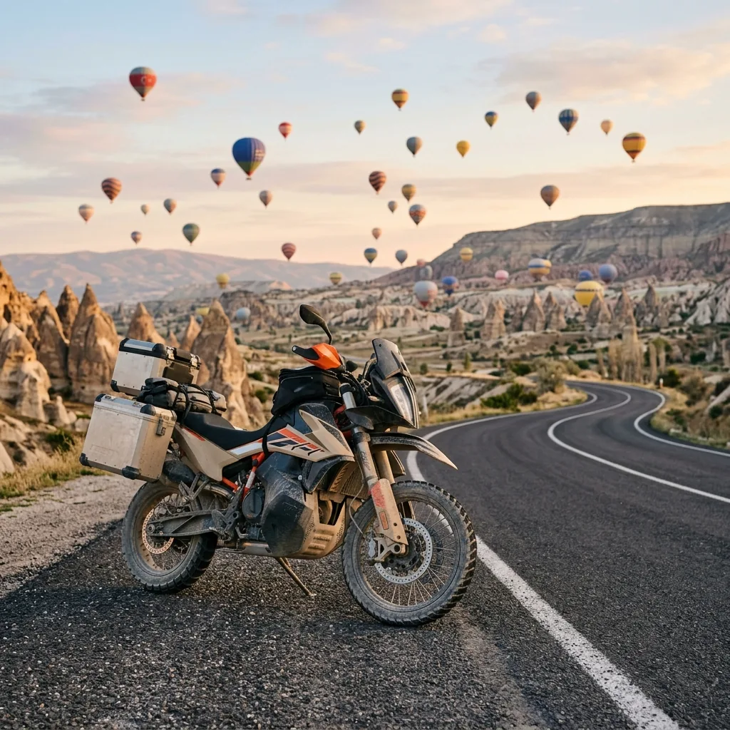
Balloons. They fly at sunrise only, and only when the weather lets them — cancellations are common in winter and shoulder season. Launch is roughly 30–45 minutes before sunrise itself. If the photo-of-balloons-overhead is what you came for, work backward: sunrise time, minus 45 minutes for launch, minus 20 minutes to be parked at a viewpoint with the camera out, minus however long it takes to ride from your cave hotel. In summer you’ll be on the bike around 04:30. In winter, closer to 06:30. You are not riding with the balloons — they drift with the wind. You park, watch, then ride.
Getting In on Two Wheels
Most riders arrive on Cappadocia as one leg of a longer Turkish loop, not as a standalone destination. The useful anchors:
- From Istanbul, it’s roughly 730–800 km and 8–10 hours of driving on a mix of motorway and trunk roads. Realistically that’s two riding days with a stop around Ankara or Eskişehir.
- From Antalya on the Mediterranean coast, it’s about 480 km north — a long but doable single day, and a great pairing with the Lycian Way route.
- From the Black Sea coast (Trabzon / Samsun), it’s a southbound plateau crossing of roughly 600–700 km, depending on the line. Two relaxed days through the Pontic foothills.
If you’re flying in to rent locally, Nevşehir Kapadokya (NAV) is the closer airport — around 40 km / 40–45 minutes to Göreme — and Kayseri Erkilet (ASR) sits roughly 60–75 minutes away on a faster motorway-style road.
Approach roads are all paved trunk routes. There’s no “rugged entry” into the region — the drama starts when you crest the last ridge and the plateau opens up.
The Core Road Loop: Two to Three Days, Base-and-Spoke
The right way to ride Cappadocia is not a continuous loop with a different bed every night. It’s a base in Göreme, Uçhisar or Ürgüp, with short morning and evening rides out to viewpoints between them. Distances are tiny — single-digit kilometres between most of the famous stops — and the value is in pacing, not mileage.
I’ve written this as a two-day skeleton you can stretch to three.
Day 1 — The Northern Loop: Göreme → Uçhisar → Ortahisar → Çavuşin → Paşabağ → Devrent → Avanos → back to Göreme
This is the postcard day. Total saddle time is well under two hours; you’ll spend six on your feet.
Leave Göreme west on the road that climbs to Uçhisar, the village built around the highest rock outcrop in the region. Uçhisar Castle is the single best panorama in Cappadocia — you can see the whole plateau, the Erciyes volcano on a clear morning, and the lines of the valleys cut into the tuff. There’s paid parking near the base and a short walk up; the bike is fine left for a couple of hours.
From Uçhisar, double back briefly and turn east on the small road toward Ortahisar, the quieter rock-cut “Middle Castle.” It’s a short ride, the village itself is gentler than Göreme, and the panorama from the castle is the one you’ll have mostly to yourself.
Loop back through Göreme and pick up the road north toward Çavuşin. This is one of the oldest continuously inhabited rock villages in the region, and the cliff churches above it are worth a stop. Continue to Paşabağ (Monks Valley) for the densest grouping of multi-cap fairy chimneys, then to Devrent (Imagination Valley), where the tuff has eroded into the camel-shaped formations that show up on every Cappadocia brochure.
From Devrent, the road drops north to Avanos, the pottery town on the Kızılırmak (Red River). It’s a good lunch stop — slower paced, riverfront restaurants, decent parking. From Avanos, ride back to Göreme via the southern road through Çavuşin again, or loop wider through the Zelve area on the way back.
End the day at the Göreme panoramic viewpoint (often called Sunset Point) above town for the light on the chimneys. Park, sit, watch.
Road notes: all paved provincial road, light traffic outside July–August, tight village streets in Uçhisar and Ortahisar where filtering on a loaded ADV needs care. There are no off-road sections on this route and there shouldn’t be — see the legal section above.
Day 2 — The Southern Spur: Göreme → Mustafapaşa → toward Cemil / Keşlik → Soğanlı
A half-day to full-day southern leg that gets you out of the busiest core and into the gentler, less-photographed Cappadocia.
Ride east from Göreme through Ürgüp, then south on the small road to Mustafapaşa (formerly Sinasos), about 5 km past Ürgüp. The village is Greek-influenced — carved stone façades, ornate doorways, a much quieter feel than Göreme. It’s a good coffee stop and a short walk through the old quarter.
From Mustafapaşa, continue south through the gentler landscape past the Damsa reservoir direction, toward Cemil and the Keşlik monastery area, then on to Soğanlı Valley — roughly an hour’s drive from Göreme, set in a remote canyon south of Mustafapaşa. Soğanlı holds 6th–11th-century rock-cut churches and almost no tourist density on a weekday. The valley is inside the protected zone — walk the marked paths, leave the bike at the village.
Return the same way, or loop back east via the Ürgüp-side road.
Road notes: paved public roads with some quieter rural stretches. Treat any unsigned dirt connector as protected by default — stay on the asphalt.
Day 3 (optional) — The Western Day Ride: Göreme → Derinkuyu → Güzelyurt → Ihlara Valley → Selime → back
This is the day that justifies a third night on the plateau. Roughly 80 km southwest from Göreme, around 1 to 1.5 hours of driving each way, into Aksaray Province.
Leave Göreme south, dropping onto the plateau road toward Kaymaklı and Derinkuyu. Derinkuyu is one of the deepest accessible underground cities in the region — multiple levels down into the tuff, with carved tunnels, ventilation shafts and stone-rolled doors. It sits roughly 10 km south of Kaymaklı, and it sits naturally on the route to Ihlara. Plan an hour underground, then ride on.
Continue west into Aksaray Province. The protected old town of Güzelyurt sits along the way and is worth a 20-minute coffee stop; its Monastery Valley is roughly 4.5 km long and a separate, smaller version of what Ihlara does on a bigger scale.
Arrive at the Ihlara Valley itself. The canyon is 14–15 km long and up to about 150 metres deep, carved by the Melendiz Stream, with more than fifty rock-cut churches along its length. The classic entry is at the village of Ihlara, where 426 steps drop to the canyon floor. From there, the popular walking section is about 3.5 km to the village of Belisırma (good lunch spot, restaurants right on the stream); the full Ihlara-to-Selime trail is closer to 13–14 km.
The valley ends at Selime Monastery — a vast cliff-carved complex at the northern end, sometimes called Cappadocia’s Cathedral. You can ride to Selime separately and walk in from that end if you don’t want to do the whole valley on foot.
Road notes: trunk roads from Göreme to Aksaray-area turn-offs, then provincial roads to Ihlara, Belisırma and Selime. All paved. The trail through the canyon is hiking only — leave the bike at Ihlara, Belisırma or Selime.
How to Ride the Valleys Legally: Book the ATV/UTV Tour
If part of you came here for the off-road sensation of riding between the chimneys, the legal way to do that is to book a licensed ATV or UTV tour. Here’s what you should expect from a properly run, authorised operator:
- They run only on a track declared and approved by the Kapadokya Area Directorate. They will not take you into museum or archaeological zones.
- The group is capped at eight vehicles, including the leader.
- Helmet, goggles and knee protection are mandatory, provided by the operator.
- You need at least a class-B driving licence to drive a tour vehicle.
- The vehicles are tracked and insured; the company holds permit documents.
Choose operators that visibly comply with this. If a tour is willing to “take you wherever you want, no problem,” that’s the signal to walk away. The whole reason the regime exists is to stop ad-hoc off-road damage in a UNESCO site; supporting compliant operators is the small bit of agency you have here.
Where to Sleep
Two honest options, plus a hard “don’t.”
Cave hotels are the right answer for most riders, and not just for the gimmick. The villages are walkable, the rooms are genuinely warm in shoulder season because the tuff holds heat, and parking is usually somewhere in the courtyard or a few metres up the street. Göreme has the widest range of price points; Uçhisar is quieter and slightly more expensive; Ürgüp feels the most “town.” Book ahead in season — every cave room visible from a viewpoint goes early.
Established campgrounds exist in the wider region, mostly on the outskirts of the protected zone, and are the right pick if you’re on a budget or running a full camping setup off the bike. Names and rates change year to year, so verify before you ride out: the wild camping in Turkey guide covers the legal landscape for the rest of the country and Park4Night / iOverlander are the practical tools for finding what’s currently open.
Wild camping in the valleys is not on the table. This is a UNESCO-listed, archaeologically dense, actively patrolled protected area. The legal exposure is real, and the ethical exposure is worse — a single tent on a tuff slope is the kind of footprint the Area Directorate exists to stop. If you want a wild bay night somewhere in Turkey, do it on the Aegean or Black Sea coasts (the Lycian guide and Black Sea & Kaçkar guide cover those properly), and treat Cappadocia as a “sleep in a village” stop.
For the rest of the camping kit — bag, mat, tent, stove, secure-storage thinking — see the motorcycle camping gear checklist, the how-to-secure-motorcycle-wild-camping post, and the solo motorcycle camping safety guide.
Practical Rider Notes
A handful of things I wish someone had told me before I rode in:
- Fuel. Stations are easy to find in Nevşehir, Ürgüp, Avanos and along the trunk roads. The southern Soğanlı and western Ihlara legs cross quieter sections — top up before leaving the main triangle. Don’t quote me current prices; they move too much to be useful in a blog post.
- Parking. Village streets in Göreme, Uçhisar and Ortahisar are narrow and busy. Use signed lots, not the kerb in front of a hotel — towing happens. At viewpoints, park well off the road; the gravel shoulders look fine and aren’t always.
- Sunrise positioning for balloons. Be at the viewpoint twenty minutes before launch, not at launch. The classic spots above Göreme and the Sunset / Red Valley side fill quickly in season. If you ride out in the dark, take a headlamp for finding a parking spot, and keep the bike lights on the road, not on a launch field.
- Leave-no-trace. The plateau is fragile in ways that don’t look fragile. Don’t ride onto soft tuff, don’t crack a piece off a chimney for a souvenir, and don’t leave wrappers at the viewpoints. It’s the most photographed landscape in Turkey; everyone notices.
- Two wheels vs the chimneys. No, you can’t legally ride a track between them on your own bike. Yes, you can ride past every famous one of them on a public road. That’s the deal. Make peace with it before you arrive — the trip is much better when you do.
Internal Connections
This post fits into the wider Turkey ride map on Bikes & Bays:
- For the Mediterranean leg that pairs cleanly with Cappadocia as a north-of-the-coast loop, see the Lycian Way motorcycle route guide.
- For the long Black Sea route that meets Cappadocia from the north, see Black Sea & Kaçkar: Amasra to Yusufeli.
- For the full cross-Turkey overland picture, see the Turkey TET route guide.
- For the camping legal landscape in the rest of the country, see wild camping in Turkey on a motorcycle.
- For loading the bike for two weeks on the plateau, see the motorcycle camping gear checklist and the pack my bike tool.
Conclusion
Cappadocia rewards a rider who arrives with the right expectations. The right expectations are short days, paved provincial roads, viewpoints over valleys you don’t drive into, a sunrise spent watching balloons from a parking spot, and a slow lunch in a village built into rock. The wrong expectations — ripping through Love Valley, wild camping under a chimney, “chasing tracks” — are not just illegal, they’re the behaviour that will eventually close the door on what makes this place ridable at all.
Give it two days minimum from a base in Göreme, Uçhisar or Ürgüp, and three if you want Ihlara. Ride it in late April–early June or mid-September–October. Book a licensed ATV/UTV tour if you want to feel the dunes under wheels, and accept that on your own bike, the road is the route.
This guide is based on personal riding in the region and on the legal framework set by Law No. 7174 and the 2020 Sporting Activities Regulation. Some links in this article are affiliate links — if you buy gear through them, we may earn a small commission at no extra cost to you.
Frequently Asked Questions
Can I ride my own motorcycle off-road through the Cappadocia valleys?
No. The valleys around Göreme, Ürgüp and Avanos sit inside the Kapadokya Area, a protected zone governed by Law No. 7174 and the 2020 Sporting Activities Regulation. Motorized off-road recreation is restricted to declared tracks operated by licensed ATV/UTV operators, and is banned outright inside museum and archaeological sites. On your own bike you ride the public roads between the towns and viewpoints. If you want the chimneys-and-dunes off-road experience, the legal way is to book a licensed ATV/UTV tour on an approved track.
When is the best time to ride Cappadocia?
Late April through early June and mid-September through October. Daytime temperatures sit roughly between 15 and 25 °C with mostly clear skies, the plateau is at its greenest in spring or its golden best in autumn, and crowds are manageable. Summer (July–August) is hot, dusty and crowded — ride early. Winter is genuinely cold and often snowy, with ice risk on shaded plateau roads and frequent balloon cancellations.
Where should I base myself for the loop?
Göreme is the obvious base — closest to the panoramic viewpoints, the easiest walk to a sunrise balloon spot, and surrounded by cave-hotel options. Uçhisar is quieter and sits at the region's highest point, which makes for very short rides to the best viewpoints. Ürgüp is the most 'town' of the three, with more parking and a wider choice of restaurants. All three work as a hub for a 2–3 day base-and-spoke ride.
Can I see the hot-air balloons from the saddle?
Only if you are already at a viewpoint before the launch. Balloons fly at sunrise only, and they lift off roughly 30–45 minutes before sunrise itself. In summer that means rolling out of the cave hotel around 04:30; in winter you have until about 06:30. You don't 'ride among' them — they drift with the wind, you stay on the road, and the photo is from a viewpoint with the bike parked, not a moving shot.
Is wild camping a good idea in the valleys?
No. The valley interiors are inside a UNESCO-listed, protected, archaeologically dense area, and pitching a tent on a fairy-chimney slope is exactly the behaviour the Area Directorate exists to stop. The legal options are established campgrounds in the wider region and cave hotels in the villages. For the broader Turkey picture see the [wild camping in Turkey guide](/blog/wild-camping-turkey-motorcycle), but treat Cappadocia itself as a 'sleep in a village' stop.