The first time I rode California’s Highway 1 was at 30 km/h behind a tour bus that wouldn’t pull off. I was on a rented Harley Sportster, my partner on the back, and we crawled the 35 miles from Carmel to Big Sur Lodge in 90 minutes watching the bus driver miss every pull-off. By the time we got to lunch I’d seen exactly zero of the road I’d come to California to ride.
That trip taught me everything about timing on the PCH. Ride early. Ride late. Ride midweek. The PCH at 7am in May with low Pacific sun on the cliffs is one of the great motorcycle roads in the world. The PCH at 2pm in July behind a sequence of rental motorhomes is a parking lot with a view.
This guide is the working version. Pacific coast highway motorcycle trip as five days from San Diego north to Mendocino, with the timing strategy, fuel planning, and weather realism that turn the route from frustration into the experience you came for.
The Road That Earns Every Cliché About It
California State Route 1 — the road locals call Highway 1, tourists call PCH, and signs call SR1 — runs 656 miles along the California coast from Dana Point in Orange County north to Leggett where it merges with US-101. The most-photographed sections (Bixby Creek Bridge, McWay Falls, the Big Sur cliffs) sit in a 100-mile stretch between Cambria and Carmel.
The full road isn’t all spectacular. Southern California from San Diego through Long Beach is mostly suburban arterial. The Los Angeles to Malibu stretch has moments but is fundamentally a city highway. The road becomes the postcard from Santa Barbara north, and reaches its peak in Big Sur.
What makes it work as a motorcycle road isn’t speed. The legal limit is 55 mph and the realistic average is 35-45 mph in the curvy sections. The road works because of the rhythm — long sweeping cliff-edge corners with the Pacific 200 meters below, sequenced for hours at a time, with pull-offs every few miles. It’s not a Bealach na Bà-style technical challenge. It’s a sustained engagement with one of the most dramatic coastlines on earth.
The Route: South to North or North to South?
South to north is the better direction for motorcycles. Three reasons.
First, the views are on your left. Northbound puts the Pacific on the rider’s left side — easier to glance at, easier to photograph, easier to position the bike for the iconic views without crossing oncoming traffic.
Second, the highlights build. Southbound burns through Big Sur in the first day from Monterey and leaves the urban LA approaches for the back half. Northbound saves Big Sur for day 3 of a 5-day trip — by then you’re settled into the rhythm and ready for the highlight.
Third, the photo stops align. Bixby Bridge, McWay Falls, and the dramatic cliff pullouts all have parking on the seaward (left) side. Northbound, you pull off across your direction of travel cleanly. Southbound, every photo stop requires a left turn across oncoming traffic.
Day 1: San Diego to Malibu (120 miles)
Start in San Diego at the Pacific Coast Highway sign near the Coronado Bridge. Ride north through La Jolla, Oceanside, San Clemente, and into Orange County. The road here is suburban — not the scenic PCH — but the beaches and the small towns make it pleasant.
By Dana Point you’re on the official southern terminus of SR1. The road continues through Laguna Beach, Newport Beach, and the Long Beach industrial corridor. This section is a slog if you’re impatient. Treat it as the warm-up; the road improves dramatically after Santa Monica.
Through Santa Monica you hit the Santa Monica Pier — the end of Route 66 if you’ve been doing both routes. Continue north on PCH along the Malibu coast. By dinner you’re in a Malibu motel watching the sun set over the Pacific.
Road notes: Multi-lane highway in urban sections, two-lane through Malibu. Lane splitting legal throughout. Marine layer common in mornings — start with a layer, peel off by 11:00.
Day 2: Malibu to Santa Barbara (105 miles)
Day 2 transitions from urban California to the coast that earns its reputation. From Malibu, ride PCH north past Point Mugu and into Oxnard. The road merges with US-101 briefly before splitting back to coastal SR1 north of Ventura.
The stretch from Ventura to Santa Barbara is one of the more underrated PCH sections. Two-lane road along beach with the Channel Islands visible offshore on clear days. Stop in Carpinteria for lunch — the small town has a beautiful beach and excellent taquerias.
Arrive Santa Barbara mid-afternoon. The city is the natural overnight before the long day to come. Stay in or near the Funk Zone (downtown waterfront district) — walkable restaurants, the State Street pedestrian area, and Stearns Wharf.
Road notes: Pleasant two-lane riding once past Malibu. Watch for cycling traffic on the Carpinteria-Santa Barbara stretch; the area is popular with road cyclists.
Day 3: Santa Barbara to Big Sur (200 miles) — The Crown Jewel

The longest single day of the trip and the one that justifies it. Leave Santa Barbara by 7am.
Ride north on US-101 (PCH joins 101 through this region) to San Luis Obispo, then back onto the coastal SR1 at Morro Bay. The stretch from Morro Bay through Cayucos to Cambria is excellent two-lane coastal road — moderate traffic, sweeping curves, views.
Stop in Cambria to fuel up. This is the last reliable gas before Big Sur. Top up even if you don’t think you need to. The next reliable fuel is Carmel, 95 miles north, with only the unreliable Gorda station between them.
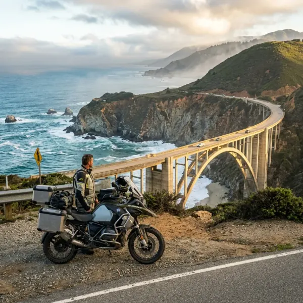
From Cambria, the road becomes the PCH of the brochures. Climb away from sea level at San Simeon, past Hearst Castle (worth a tour if you have time but a half-day commitment), and enter Big Sur proper at Ragged Point. The next 90 miles north to Carmel are continuous cliff-edge cliffs, hairpin sequences, and ocean views that don’t stop.
Key stops on the Big Sur section:
- McWay Falls (mile 37 from Carmel) — 80-foot waterfall directly onto the beach, viewed from a short trail off the pullout
- Big Sur Lodge / Pfeiffer Big Sur State Park — accommodation, food, and the gateway to the Pfeiffer Falls hike
- Nepenthe restaurant — clifftop dining with the most-photographed view on the highway
- Bixby Creek Bridge (mile 13 from Carmel) — 280-foot single-span arch, the iconic PCH photo
Plan to arrive at your Big Sur accommodation by 17:00. The road is technical enough that riding it after dark is a real safety degradation.
Road notes: Narrow two-lane, no shoulder in most sections, frequent pullouts. Landslide closures possible — check CalTrans before riding.
Day 4: Big Sur to San Francisco (150 miles)
Continue north out of Big Sur to Carmel and Monterey. Carmel-by-the-Sea is worth a morning stop — the town is famously walkable and has the Carmel Mission worth 30 minutes. 17 Mile Drive between Carmel and Monterey is a private road requiring a $12 fee but worth it for Pebble Beach views.
North of Monterey through Santa Cruz, the road runs along sandy beaches and through small surfing towns. Half Moon Bay (45 miles south of San Francisco) is the natural lunch stop — Sam’s Chowder House is the local institution.
The approach to San Francisco from the south on PCH is one of the great urban arrivals. The road climbs from Pacifica, passes through Devil’s Slide tunnel, and delivers you across the Golden Gate Bridge from the south side. Cross the bridge as part of the arrival — it’s the iconic moment.
Stay in San Francisco or Sausalito (just across the bridge). Both work, Sausalito is quieter and easier for motorcycle parking.
Road notes: Mixed urban and coastal. Heavy traffic approaching SF — lane splitting helps. Marine layer can persist in SF into the afternoon; bring layers.
Day 5: San Francisco to Mendocino — The Forgotten North (100 miles)
The PCH north of San Francisco is the section most riders skip and the one I’d recommend the most. The route goes through Marin County, into the redwoods, past Point Reyes, and up the coast to Mendocino.
The first 30 miles north of SF are pleasant but unremarkable. Past Point Reyes Station, the road becomes the wild coastal route — fewer cars, more trees, dramatic Pacific views. The stretch from Bodega Bay through Jenner to Stewarts Point is a sequence of cliff-edge corners and redwood-lined climbs that rivals Big Sur for pure riding pleasure with a tenth of the traffic.
Mendocino is the natural endpoint. The town is a preserved 19th-century coastal village turned arts community. Stay one night, eat dinner at MacCallum House, and either turn around the next day or continue inland through the redwoods to US-101 for the return.
Road notes: Two-lane the entire way, light traffic outside summer weekends, fewer services. Carry water and snacks; restaurants are concentrated in towns 20-40 miles apart.
PCH Motorcycle Packing Checklist
What you actually carry beyond standard touring gear:
- Layered clothing for 30°C morning-afternoon swings (0 g — worn)
- Rain layer always accessible not buried in panniers (400 g)
- Reservations confirmed for Big Sur — no last-minute camping (0 g)
- CalTrans road conditions checked day before and morning of (0 g)
- Fuel range confirmed before entering Big Sur stretch (0 g)
- Camera or phone mount for bridge and waterfall stops (100 g)
The layering point is more important than it sounds. A typical PCH morning starts at 12-15°C in marine layer fog. By midday the sun burns off the layer and temperatures hit 22-28°C. Riding in a single thick textile suit means you’re cold in the morning and overheated by noon. A vented mesh jacket with a removable thermal liner is the right kit.
Check Packable Rain Suits on Amazon →
Check Waterproof Tank Bags on Amazon →
Fuel and Road Condition Planning
The two non-negotiables for PCH riding.
Fuel: Fill at Cambria southbound entering Big Sur. Fill at Carmel northbound leaving Big Sur. Do not trust the Gorda or Big Sur Station to be open. Both are expensive and frequently closed. A full tank at the boundary stations covers the 95-mile Big Sur section without anxiety.
Road conditions: Check the CalTrans QuickMap (https://quickmap.dot.ca.gov) the morning of every Big Sur riding day. Highway 1 closures from landslides can require 100+ mile detours via Salinas and US-101. Better to find out at breakfast than at the closure barrier.
Internal Connections
For complementary US-region riding, see Route 66 motorcycle trip cost and packing. Many riders combine the two routes into a 3-week California-and-Southwest trip — fly into LA, rent a bike, do Route 66 east to Chicago and back, then PCH north to San Francisco.
FAQ
Five common questions are answered at the top of this page. The short version: ride south to north, give it 5 days, book Big Sur 3-6 months ahead, fuel at Cambria, check CalTrans daily, and layer for marine layer mornings.
Whatever your version of a pacific coast highway motorcycle trip looks like, the road rewards riders who time it right and don’t try to ride it fast. The PCH at 35 mph in early light is the experience. The PCH at 25 mph behind a motorhome at noon is not. Plan accordingly.
Disclosure: Some links in this article are affiliate links. If you buy gear through them, we may earn a small commission at no extra cost to you.
Frequently Asked Questions
South to north or north to south on the PCH?
South to north for motorcycles. The northbound direction puts the ocean on your left — easier to glance at while riding, and the photo stops (Bixby Bridge, McWay Falls) line up on the inside of your line of travel. Northbound also rides Big Sur with the dramatic cliffs on the seaward side, which feels more committing. Most riders go south to north; the only real reason to go north to south is if it matches your trip logistics.
Do I really need to book Big Sur accommodation 6 months ahead?
For camping at the named state parks (Pfeiffer Big Sur, Andrew Molera, Limekiln) — yes, 6 months is realistic for summer weekends and 3-4 months for weeknights. For motels along Highway 1 in Big Sur (Big Sur Lodge, Ripplewood, Glen Oaks), book 3-4 months ahead. For Carmel and Monterey just north, 6-8 weeks ahead is usually enough. The single hardest accommodation to get is a campsite at Pfeiffer Big Sur in July or August.
Is Big Sur really closed all the time due to landslides?
Frequently. Highway 1 through Big Sur has suffered multiple major landslides since 2017 — the Mud Creek slide (2017-2018), the Rat Creek slide (2021), and various smaller closures. As of 2026, the route is mostly open but check CalTrans before riding. Closures can require detours of 100+ miles via Highway 101. The CalTrans road conditions page (https://roads.dot.ca.gov) is the authoritative source; check the night before and the morning of riding the section.
Where can I fuel up before the Big Sur section?
Last reliable fuel southbound is in Cambria. Last reliable fuel northbound is in Carmel. Between them, the only fuel is at Big Sur Station and Gorda — both expensive ($6+/gallon vs $4-5 in Carmel), often closed, and not always reliable. Fill before you enter Big Sur with a full tank. A bike with 150-mile range handles the section without issue. A 100-mile-range bike needs careful planning.
Is lane splitting legal in California?
Yes. California is the only US state where lane splitting (riding between lanes of slow or stopped traffic) is explicitly legal under California Vehicle Code §21658.1. The California Highway Patrol publishes guidelines: split at speeds no more than 10 mph faster than surrounding traffic, only when traffic is moving 30 mph or slower, and not on the shoulder. PCH itself rarely has multi-lane traffic where splitting helps, but the urban approaches (LA, San Francisco) absolutely do.